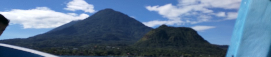
On the northern foot of Volcán Tolimán is a lesser climbed lava dome, Cerro de Oro (“Hill of Gold”). The hike and summit provide gorgeous views of Lago Atitlan, Volcán Tolimán, Volcán San Pedro, and Volcán Atitlán.
And… we discovered a Mayan ceremonial site along the way, and some ancient Mayan stone statues at the summit.
The most popular volcano to climb is San Pedro, but that requires a good 5am departure and a full day to climb. Atitlan and Toliman are even more difficult to get to, require more logistics, and take a full day plus to climb.
In contrast, for Cerro do Oro, round trip, our moving/hiking time was about 90 minutes to the top and back down. We took much longer, though, as we stopped often for photos and views.
You can get to Cerro de Oro by taking a ferry/launch to Santiago and then arranging for transport there by road, or, what we did was hire a private launch to go directly to Cerro do Oro (and back) from Panajachel where we were staying.
The town of Cerro de Oro doesn’t get many tourists and it’s not a common spot to take a boat. Many boat captains may never have been there. Our captain, Erik, and his son, found a place to dock, and then joined us for the hike as it was their first time on the lava dome. They enjoyed themselves and took plenty of selfies along the way, too!
Round trip for the 4.5 of us across the lake and back, our private ferry cost us Q.500 (~$64 US) and took maybe 10-15 minutes each way. The lake is calmer in the morning and gets windier/choppier/rougher later in the day.
Once docked, head up and into town, taking a left before the big yellow church.
If you need a restroom wait until you’re in the woods or if it can’t wait, they will all cost you Q.2 ($0.25 US) and can be found either at the dock or further up in town if you ask around.
From there follow the road until you get near the soccer field, and then vear off and into corn field and subsequent woods taking an unnamed trail used by the locals to gather fire wood.
The trail comes back out to the main road you were on before and as you head further, you’ll see a pedestrian crossing sign and the trail will pick up again to your right.
Follow the rough trail up and through the woods until you see a ceremonial site. Enjoy the views and then continue to the right of the site higher up.
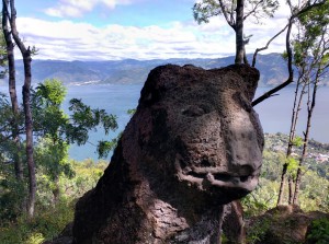 When you get to a flatter camp area, again, enjoy the views and take some photos, but then head left from camp to higher ground until you come to an ancient stone carving of what appear to be a lion and a frog.
Continue on past those until you reach some light rock scrambling and the final summit with awesome views of Volcán Tolimán.
Reverse course for your descent down and when you hit the road, you can simply take that all the way back down into town if you like and skip the last section of trail.
Once back in town, we stopped at one of the many storefronts and enjoyed some ice cold beers and snacks.
This was a super fun hike and fit our timeline of hiking in the morning and being back to Panajachel in time for lunch.
Below is our Strava route. You can also download the Cerro do Oro GPX.