There is shockingly little information about SUPing on Lexington Reservoir in Los Gatos. I figured it out the hard way and here is everything you need to know.
For starters, yes you can SUP at Lexington Reservoir County Park.
There are 2-3 fees you’ll need to pay when you arrive and all can be paid online ahead of time or in person by credit card using the machine. Apple Pay and cash are not supported so bring a physical card if you don’t pay online.
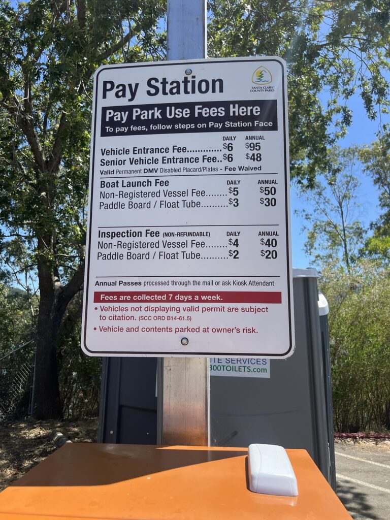
First, you pay for your parking for the day ($5) or for the year with an annual pass. You put that receipt on your dashboard for the rangers to see.
Next, you pay a “launch fee” to put your SUP in the water for the day ($3) or for the year with an annual pass. You show that to the rangers when you walk by on your way down to the launch.
Lastly, if it’s your first time visiting or if your SUP was in a different body of water last, you pay for a “vessel inspection” ($2) which is pretty quick. You pay the fee and walk over to the ranger trailer, show them your receipt, and they take a look and then tag your SUP with a little bracelet sticker.
Those are the only three fees.
You have to pay for each fee individually, so your credit card will have three back to back small transactions from the same machine within a few minutes of each other. We saw other visitors have the third transaction declined by their bank and they needed to use another card, but that didn’t happen to us.
SUP Vessel Registration
The last thing you’ll need to deal with is a one pager Vessel Registration of sorts. They’ll hand you a clipboard, you write down information like who you are, what car you’re in, what color and model the SUP is, etc, and they keep that on file. And it’s good for the rest of the calendar year.
You can also complete the Vessel Registration Declaration Form online ahead of time and bring it with you.
Personal Flotation Devices (PFDs)
Kids under 13 are required to wear PFDs (life vests) and adults are recommended to have/wear them.
We already had adult PFDs and picked some up kid size PFDs at Bass Pro Shops.
Parking, Restrooms, and Boat Launch
There is plenty of parking and at Lexington Reservoir County Park are a bunch of portapotties in the parking lot.
To get there, you either come down from Summit Road, or exit from Highway 17 (Northbound only). The address for the parking lot is 17770 Alma Bridge Rd.
You can carry your board down the ramp into the water or you can back your vehicle down the ramp and launch that way.
We just carried down and it was fine.
Where to SUP on Lexington Reservoir?
Once you’re on the water, the reservoir has a delightful perimeter to explore.
The shoreline meaders around and to all kinds of little outlets and coves. It’s super peaceful and quiet on the water with so many different kinds of birds to see everywhere you go.
Depending on when during the year you go, the permititer and outlets vary, but when we’ve gone mid-summer, it’s barely 3km around. I’m guessing in the winter it may be closer to 5km.
Be mindful that the winds do shift out on the reservoir, and you may find some waves and strong headwinds while you’re out. That classically happens when you’ve reached the far end of the reservoir and want to head back and have headwinds for the entire return!
Once you’re out on the water, be mindful that “swimming is prohibited”. If you fall off, obviously that’s okay, you get back on your SUP. But they prohibit swimming so there are no lifeguards or patrols or anything like that. That being said, we saw plenty of families off their SUPs swimming around. Some areas near shallow water with lots of birds have less water flow and in turn pretty gross water, so you wouldn’t want to “fall in” there.
Lexington Reservoir SUP Frequently Asked Questions
Parking is $5 for the day. You can also buy an annual pass.
You’ll park at the county park lot, 17770 Alma Bridge Rd, accessible from highway 17 (Northbound) or Summit Rd.
The parking lot has porta potties and the little foot pump powered wash stations, but there is not running water or anything like that.
No, SUPs do not require a California Boater Card. Those were required starting in 2025, but only for motorized vessels.
Contrary to what the county website will lead you to believe, no, you don’t need to register your SUP with the DMV. The “M” in DMV is for Motor and your SUP does not have a motor.
Instead, you’ll show your driver’s license and put down information about the registered vehicle you arrived in, i.e. your car.
Contrary to what the county website says, no, you don’t need to purchase a Mussel Sticker from the state. You do need to have your SUP inspected by the rangers and you’ll get a tag for your SUP, but that’s different.
Yes, you’ll need to have the ranger inspect your SUP and you’ll pay a small fee ahead of time for that. They take a quick look and put a tag on your SUP to show it was inspected at Lexington Reservoir. The next time you SUP at Lexington, so long as you haven’t been anywhere else in between, it should still be valid and shouldn’t need another inspection or fee.
If you do SUP somewhere else in between, they’ll inspect at that location, remove the Lexington tag, and put their own tag on. Then you’ll need another inspection at Lexington.
Technically “swimming is prohibited” in Lexington Reservoir, but falling in is understandable and you can get back on your SUP. But… we saw plenty of folks off their boards enjoying the water.
Vessels are not available to available to rent at Lexington. If you’re looking to rent, you can do that at Vasona Lake County Park in Los Gatos or at Stevens Creek County Park in Cupertino. You’ll find minimum age restrictions for rentals, though.
Enjoy your time out on the water. There are plenty of SUPs out there and it’s a ton of fun for the whole family!